Key Takeaways
- Both Google Maps and Apple Maps are accurate & provide reasonable arrival times and similar routes for driving.
- Google Maps offers more detailed traffic and hazard information compared to Apple Maps.
- Apple Maps offers ridesharing information while Google Maps has music controls and satellite maps, making it slightly preferable.
When Apple launched Apple Maps, it’s fair to say that the reception was less than ideal. Many iPhone users weren’t happy about the fact that Apple had replaced Google Maps with something that at the time was far less useful.
However, Apple Maps has improved a lot since it first appeared in 2012 and is now able to give Google Maps a run for its money. But which navigation app should you use? I went head-to-head with Google Maps vs. Apple Maps to see which came out on top.
5 reasons why I use Waze over Google Maps
Google has two free navigation apps. Here’s why, after all these years, I still use Waze over Google Maps.
Driving navigation
A very similar experience
Both Google Maps and Apple Maps offer a number of different navigation options, but for many people, the apps will be used most for driving. How do the apps compare when used as a satellite navigation app in a car?
Both apps allow you to enter both a starting point and a destination for your journey, although by default the starting point is selected as your current location. You are then given a choice of route options.
Unlike Waze, Google Maps and Apple Maps tend to favor the easiest routes from A to B rather than the absolute fastest. Waze will often take you on some strange detours to shave off a few minutes, but Apple Maps and Google Maps both tend to be more straightforward.
Both apps generate similar routes, although the estimations of the journey times are a little different. For the same 325-mile journey, Google Maps gives an estimation of 6 hours and 2 minutes, while Apple Maps suggests the journey will take 5 hours and 50 minutes. On the whole, I’ve found that neither app is obviously more accurate than the other; both provide reasonable arrival times, and it’s not the case that one app is always further out than the other. Overall, the experience of using both apps purely for driving from A to B is fairly similar, and both can do a good job.

How to easily find elevation in Apple Maps
You can see the elevation for walking routes and major cities in the Apple Maps app. Here’s how — via your iPhone, iPad, Mac, or Apple Watch.
Traffic and other information
Google Maps offers more detail

Isaac Mehegan on Unsplash
Both apps can also show areas of heavy traffic on the route, using a color-coded system, with heavier traffic in amber and very slow traffic in red. This traffic information does seem to show up a little more often in Google Maps, however. Google Maps also shows issues such as speed cameras on the route overview, which Apple Maps doesn’t do.
Both apps allow users to report issues such as car accidents, speed traps, and other hazards, with this information then becoming available to other app users. However, Google Maps allows you to submit a wider range of reports, including congestion, roadworks, lane closures, stalled vehicles, and objects on the road.
This means that if you’re using Google Maps, you are more likely to get information on these types of hazards. However, this relies on other Google Maps users submitting these reports, and as the feature isn’t a central part of the app, this is likely to happen less frequently than it would with an app built around social interactions, such as Waze. Still, Google Maps can provide more detailed hazard information than Apple Maps can.

I tested Google Maps against Waze to see which is actually better
Google owns two navigation apps: Google Maps and Waze. I use Waze, but I downloaded Google Maps to see how it compares.
Accuracy
Both apps are pretty accurate

I haven’t used Google Maps or Apple Maps as much as I have Waze, but when testing out both apps, I didn’t find any obvious inaccuracies. Both apps gave reasonable ETAs for my journeys, which proved to be reasonably accurate, and both updated the ETA during the journey based on the journey to date and the traffic conditions for the remainder of the journey.
I felt confident that both apps were providing me with accurate information at all times. Obviously, user-submitted hazard reports may not always be accurate, but this is only to be expected with user-generated information.

How often does Google Maps update Street View?
Can’t wait for your renovated house to show up on Google Street View? Here’s what you need to know about how the feature gets updated.
Other navigation options
Flights in Google Maps, ridesharing in Apple Maps

Both apps offer far more than just driving directions. You can get walking and cycling directions in both apps, as well as public transport information for getting from one destination to another.
However, each app offers its own unique feature, too. In Google Maps, you can search for flight routes to get you from one location to another. If you enter two major cities, for example, Google Maps will tell you how long it would take to fly from one to the other via any direct flights, how long it will take with connecting flights, give you a rough idea of the cost, and provide a link to see the flights on the Google website. It’s somewhat useful, but you’re far more likely to search for flights directly via a dedicated website or app.
Apple Maps offers a ridesharing option. This will show you estimated wait times and fares for services such as Uber if you have those apps installed on your iPhone. You can then tap a fare to open the app and book it. This feels like a more useful feature than the flight info in Google Maps and one that you’re likely to use more often.

I tested Apple Maps against Waze to see which is actually better
If you own an iPhone, Apple Maps comes pre-installed, but is it better than others? I go head-to-head with Apple Maps vs Waze to see which wins.
Local discovery
Both apps offer a lot of useful info

Both Google Maps and Apple Maps allow you to search for specific amenities on your journey, such as gas stations and places to eat. Apple Maps allows you to search for restaurants, gas stations, coffee shops, parking, grocery stores, and banks and ATMs. Google Maps lets you search for gas stations, restaurants, coffee shops, supermarkets, rest stops, and hotels.
In both apps, if the amenity you’re looking for isn’t one of the defaults, you can enter it in the search bar. For example, you can search for “hotels” in Apple Maps or “ATMs” in Google Maps and see results for those amenities. Overall, both apps offer a very similar experience in this regard and allow you to add multiple stops to your journey.
Both apps can also provide some information about your destination as well. For example, in Apple Maps, if your destination is a major city, you can see information such as the population, area, and elevation of the city. You also get a snippet of the Wikipedia entry for that location and some useful tour guides. In some cities, you can even access the Flyover feature, which flies you over a 3D map of the city showing off some of the key landmarks.
In Google Maps, you don’t have the same information about the city, but you do get useful information such as hotels nearby, and a list of landmarks and tourist attractions you may want to visit. You can also see user reviews of places to visit in the location. Google Maps also offers a similar feature to Apple’s Flyover for some locations, known as Immersive View. This allows you to manipulate a 3D view of the location, and you can even fast-forward through time to see how it will look later in the day or at night.

How to quickly find your parked car with Apple Maps on iPhone
Apple’s parked car feature can be a real lifesaver when you’re new to a city or unfamiliar with an area. Here’s how to turn it on and use it.
Additional features
Apple lacks controls for its own music app

Both Google Maps and Apple Maps allow you to download maps for offline use.. This means that you can continue using the maps even if you don’t have a network connection. It’s a useful feature, especially if you’re going abroad and may not have access to an internet connection while driving.
One useful feature that Google Maps has, which isn’t offered by Apple Maps, is the ability to add Apple Music or Spotify controls directly to the map screen. This means that you can control your music from the Google Maps screen without needing to switch to a different app. It’s a bit odd that you can control Apple Music from within Google Maps, but you can’t do the same in Apple Maps. When using Apple Maps while driving, I found that I would use my Apple Watch to skip tracks or pause the music, rather than having to use Siri.

10 hidden Google Maps features, tips, and tricks to try
We’ve all used Google Maps to get from A to B, but did you know it has an AR view? We’ve rounded up secret Google Maps features you might not know.
Design
Google Maps offers more detail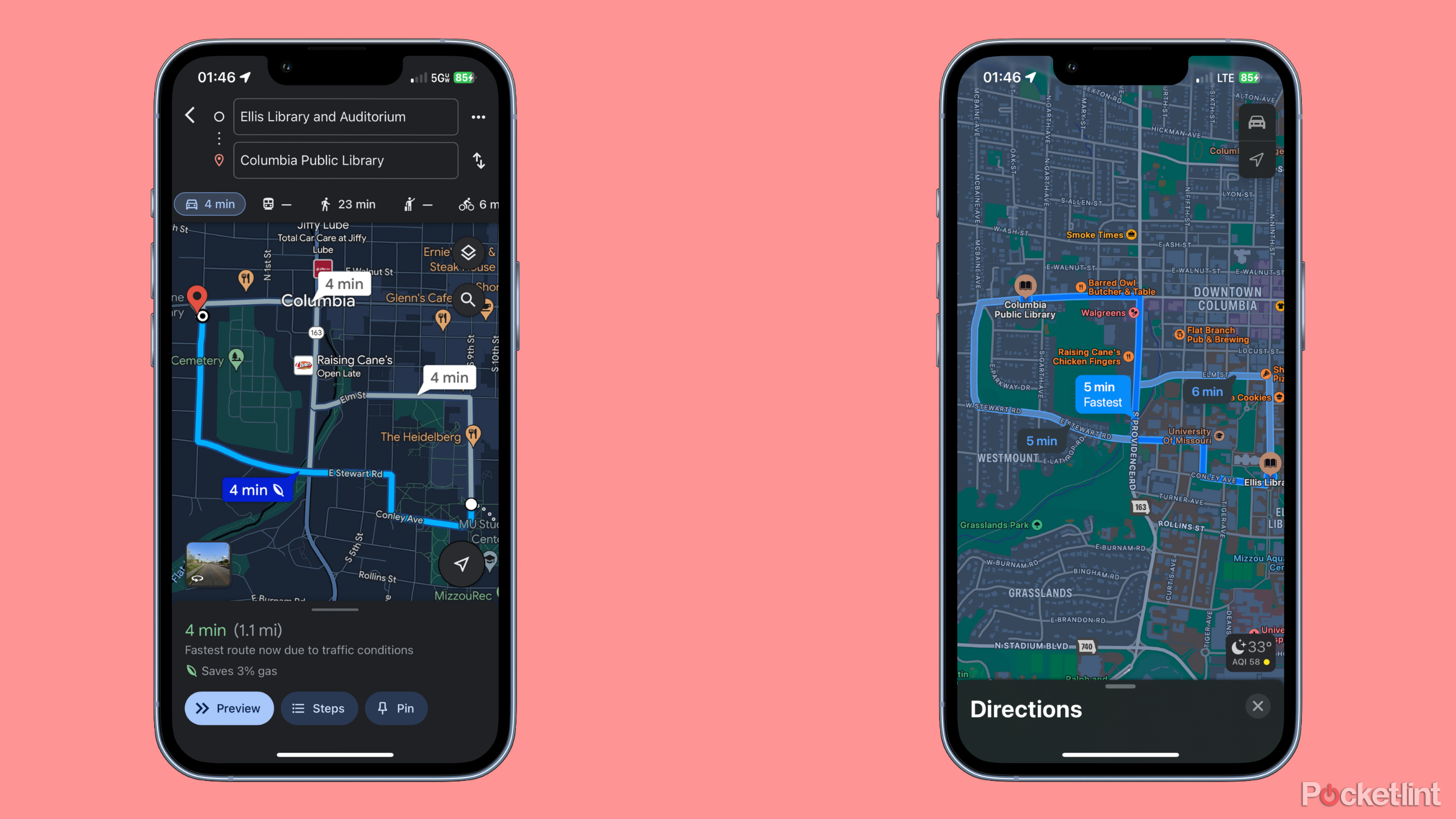
Both apps offer a fairly similar design overall, but Google Maps has one key difference; the maps displayed on the main screen when you’re navigating using Google Maps are satellite maps that show a realistic image of the area around you. In comparison, Apple Maps uses a more abstract representation of your surroundings, with gray shapes indicating buildings and light green areas showing fields. It feels less cluttered than Google Maps but may also be less helpful when you reach your destination, as Google Maps can show you exactly what your surroundings look like.

What is Google Maps Immersive View and how can you use it?
Learn how to explore a new place from the comfort of your home with Google Maps Immersive View.
Google Maps vs Apple Maps: Which is better?
Apple Maps is closing the gap
There’s little to choose between Apple Maps and Google Maps these days. When Apple Maps first launched, it was a poor relation to the dominant Google Maps, but Apple Maps has caught up significantly. The app that you ultimately choose to use will depend on several factors. If you want an app that can offer ridesharing suggestions, for example, then Apple Maps is your only option. But if you want to be able to control your Apple Music or Spotify tunes from your navigation app, then Google Maps is what you’ll need.
|
Google Maps |
Apple Maps |
|
Directions for driving, cycling, walking, public transport, and flights |
Directions for driving, cycling, walking, public transport, and ridesharing |
|
Wide choice of incident reporting options |
Limited incident reporting |
|
Accurate journey times |
Accurate journey times |
|
Local discovery with multiple stops |
Local discovery with multiple stops |
|
Offline maps available |
Offline maps available |
|
Music controls for Apple Music and Spotify |
No music controls |
|
Satellite maps |
Simplified maps |
|
Hotel and tour options |
Useful city information |
If you don’t have specific needs, then it really is a fairly close call. For my money, Google Maps is still probably a little better. I’ve not personally experienced any unusual routes using Apple Maps, but some people have had issues with this in the past. The music controls in Google Maps are also really useful when you’re driving, and it’s crazy that Apple doesn’t let you control its own music app when Google Maps does. To be honest, though, you should get a decent experience using either app.
FAQ
Q: Which devices support Google Maps and Apple Maps?
Google Maps is available on Android, iOS, Windows, and Mac devices, as well as through Apple’s CarPlay. Apple Maps is exclusive to Apple devices, including iPhones, iPads, and Mac computers.
Q: Does Apple Maps have a Google Maps-like street view?
Google Maps offers extensive street view coverage in many locations worldwide, allowing users to explore areas from ground level and providing immersive navigation experiences. Apple Maps offers a similar feature called “Look Around,” which provides street-level imagery in select cities, but its coverage is currently more limited compared to Google Maps’ Street View.
Trending Products